


|
 Hollywood, JSC
Mendocino, JSC
LA SOCIETY
SF SOCIETY
NY SOCIETY
Open START Drills
Hollywood, JSC
Mendocino, JSC
LA SOCIETY
SF SOCIETY
NY SOCIETY
Open START Drills
 Talk Daily Commodities Review LATPACT Open Market Equities Report Currency Central
 Insider: Situation US
 |

|

|

|
 |
SOCIETY Trust Fund LATPACT Trust Fund LATPACT Open Market Far West (SEZ) Trust RIM of Nations Trust
Arctic Pact Trade Zone | Upper Rhine Zone | Lower Rhine Zone | Middle Rhone Basin
| Level 2 - Open START/*Super Grid |
| Level 3 - Stellar Fields |


Climate Central News & Information
 "US attempts to salvage the European Order with an Oceania based clan-style coalition"
Population Conversations: 1,052,567
Planet Power Seconds
 Glance at NATO
 In early 2018, UNITED STATES ARMY COMMANDER, GENERAL CURTIS M. SCAPARROTTI delivered the posture statement for NATO. He stated, "As our most significant trading partner, Europe is vital to promoting American prosperity. With shared history and values, Europe is also a critical partner in advancing American influence throughout the world. The North Atlantic Treaty Organization (NATO) enables us to preserve peace through strength as alliance unity fundamentally deters the aggression of potential adversaries."
Moreover, General Scaparrotti said, "Russia continues to destabilize regional security and disregard international norms, which have preserved the peace in Europe since 1945. Russia seeks to change the international order, fracture NATO, and undermine U.S. leadership in order to protect its regime, re-assert dominance over its neighbors, and achieve greater influence around the globe. To achieve these ends, the Kremlin is prepared to employ the full spectrum of Russia’s power, to include forcefully using its increasingly capable military."
United Nations Command: AUKUSA/Quad 4
 Extensively, the Central Basin is transforming international security while disabling NATO, AUKUSA and the Quad 4 military alliances with the Open START Hawaii and Open START Alaska drills. Inherently, the Central Basin fleet suppresses the UN Command over security backlogs as the Global South impedes expansion for the Japanese yen. Economically, the US dollar bounds NATO, AUKUSA and the Quad 4 alliances under one entity in the wake of the 2007 housing crises, COVID-19 recovery and war in Ukraine. Generously, the Upper Rhine pass bridges the Open START Hawaii and Open START Alaska drills which stabilize international and climate security. Uniquely, Open START drills for the Upper Rhine pass pegs the value of the Japanese yen and Korean Won to the Chinese yuan, Indian rupee, Russian ruble, and Mexican peso to enable economic transformation for the Central Basin region. Effectively, the Open START drill secures the yen in cooperation with the Global South as significant growth on the New Silk Road Economic Belt extends in Africa. Suitably, the Open START drill baffles the UN Command with the Upper Rhine pass as the historical value is at stake. Judiciously, the Open START drill isolates the UN Command over Level 1 protocol which underpins NATO, AUKUSA and the Quad 4 military alliances to Celtic Briton tribes.
The OSCE and NATO: From the Arctic Circle
 Historically, military conflicts include land navigation rivalry which is significant for the Lower Rhine corridor as tensions between the Eastern and Western hemisphere ignite over political testimony. Substantially, the US has interspersed armed forces in the EU with the connivance of NATO and the OSCE to subjugate the Arctic Circle and dominate international trade from the Middle East. Tacitly, the OSCE is equipped to engineer early warnings, conflict resolution and crisis management over military tensions with NATO to inseminate the world order of law and justice. Decisively, the Open START Iceland drill unify the corners of the world to combat the historical West from the Arctic Circle over climate security, war crimes and crimes against humanity. Particularly, normalized ties to Israel for the Lower Rhine corridor weighs over rising Eastern influence from the Near East which is a major factor in the Open START Iceland drill. Efficiently, the Open START Iceland drill balances political, economic and military parity between the historical East and West which is threatened from the incumbency of trade sanctions and escalating military tensions in the West.
*Schedule of Nuclear Attack
Be advised: The specific plan of attack for Rhode Island is sensitive and will be posted here closer to its scheduled strike.
Rhode Island
AL* | AZ* | AR* | CO | CT | DE | FL | GA | ID | IN | IA | KS | KY | LA | ME | MD
MA | MI | MN | MO | MT | NE | NV | NH | NJ | NM | NY | NC | ND | OH | OK | OR | PA | RI | SC
SD | TN | TX | UT | VA (DC)** | VT** | WA** | WV** | WI** | WY**
*Central Fleet South  Bulava + RT23 Cadet + Vysota3
Team: Memphis Fire (Local Area Control)
**Central Fleet North Bulava + Surya + Vysota3
Open START (RKS) |
Groups UR213 - UR218 | *300kt | Millineum Power *4,000 MW
Level 1 - WA Dong (SIT.2) 
Rhode Island |
Latitude Coordinate |
Longitude Coordinate |
|
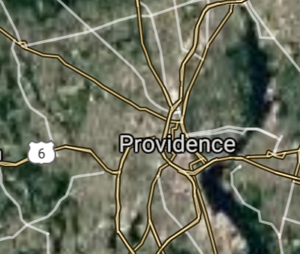
Providence [*elevation ceiling = 40km]Elevation: 3m (Group 213)
UR-100N (SLBM) |
Point A: 41.823989 00(300kt)
Point B: 41.700101 00
Point C: 41.779823 00
Point D: 41.878711 00
Point E: 41.813712 00
Point F: 42.002876 00
Open START Passages |
Point A: -71.412834 00(300kt)
Point B: -71.416167 00
Point C: -71.437280 00
Point D: -71.382556 00
Point E: -71.370054 00
Point F: -71.514784 00
Demonstration |
|
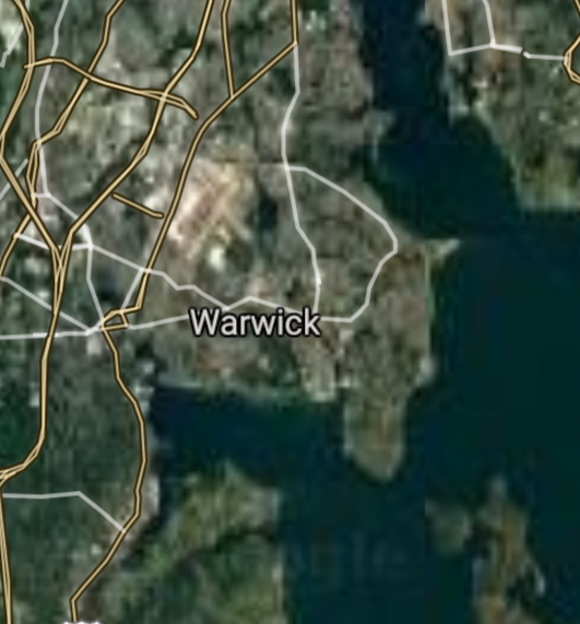
Warwick [*elevation ceiling = 40km]Elevation: 5m (Group 213)
UR-100N (SLBM) |
Point A: 41.823989 00
Point B: 41.700101 00(300kt)
Point C: 41.779823 00
Point D: 41.878711 00
Point E: 41.813712 00
Point F: 42.002876 00
|
Point A: -71.412834 00
Point B: -71.416167 00(300kt)
Point C: -71.437280 00
Point D: -71.382556 00
Point E: -71.370054 00
Point F: -71.514784 00
|
|
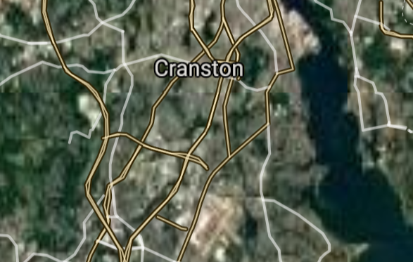
Cranston [*elevation ceiling = 40km]Elevation: 20m (Group 213)
UR-100N (SLBM) |
Point A: 41.823989 00
Point B: 41.700101 00
Point C: 41.779823 00(300kt)
Point D: 41.878711 00
Point E: 41.813712 00
Point F: 42.002876 00
|
Point A: -71.412834 00
Point B: -71.416167 00
Point C: -71.437280 00(300kt)
Point D: -71.382556 00
Point E: -71.370054 00
Point F: -71.514784 00
|
|
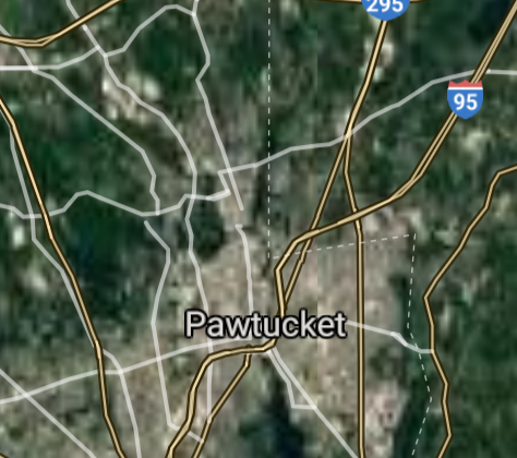
Pawtucket [*elevation ceiling = 40km]Elevation: 12m (Group 213)
UR-100N (SLBM) |
Point A: 41.823989 00
Point B: 41.700101 00
Point C: 41.779823 00
Point D: 41.878711 00(300kt)
Point E: 41.813712 00
Point F: 42.002876 00
|
Point A: -71.412834 00
Point B: -71.416167 00
Point C: -71.437280 00
Point D: -71.382556 00(300kt)
Point E: -71.370054 00
Point F: -71.514784 00
|
|
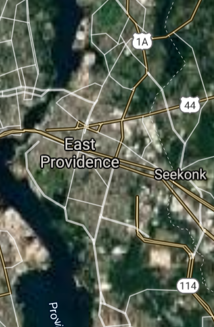
East Providence [*elevation ceiling = 40km]Elevation: 19m (Group 213)
UR-100N (SLBM) |
Point A: 41.823989 00
Point B: 41.700101 00
Point C: 41.779823 00
Point D: 41.878711 00
Point E: 41.813712 00(300kt)
Point F: 42.002876 00
|
Point A: -71.412834 00
Point B: -71.416167 00
Point C: -71.437280 00
Point D: -71.382556 00
Point E: -71.370054 00(300kt)
Point F: -71.514784 00
|
|
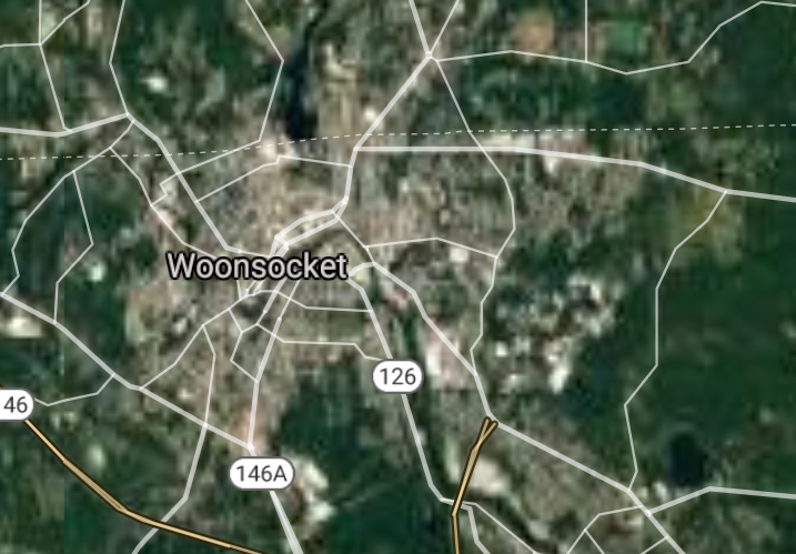
Woonsocket [*elevation ceiling = 40km]Elevation: 59m (Group 213)
UR-100N (SLBM) |
Point A: 41.823989 00
Point B: 41.700101 00
Point C: 41.779823 00
Point D: 41.878711 00
Point E: 41.813712 00
Point F: 42.002876 00(300kt)
|
Point A: -71.412834 00
Point B: -71.416167 00
Point C: -71.437280 00
Point D: -71.382556 00
Point E: -71.370054 00
Point F: -71.514784 00(300kt)
|
|
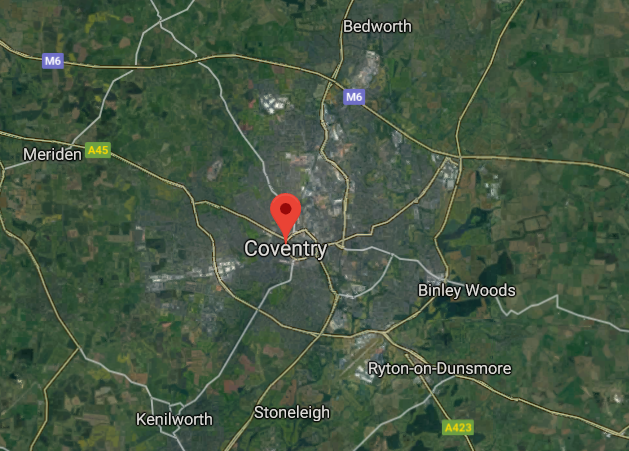
Coventry [*elevation ceiling = 40km]Elevation: 69m (Group 214)
UR-100N (SLBM) |
Point A: 41.686990 00(300kt)
Point B: 41.943855 00
Point C: 41.853552 00
Point D: 41.447569 00
Point E: 41.703671 00
Point F: 41.820520 00
|
Point A: -71.560729 00(300kt)
Point B: -71.402771 00
Point C: -71.467664 00
Point D: -71.524667 00
Point E: -71.521502 00
Point F: -71.512617 00
|
|
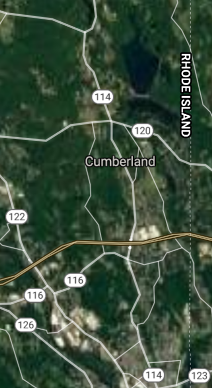
Cumberland [*elevation ceiling = 40km]Elevation: 76m (Group 214)
UR-100N (SLBM) |
Point A: 41.686990 00
Point B: 41.943855 00(300kt)
Point C: 41.853552 00
Point D: 41.447569 00
Point E: 41.703671 00
Point F: 41.820520 00
|
Point A: -71.560729 00
Point B: -71.402771 00(300kt)
Point C: -71.467664 00
Point D: -71.524667 00
Point E: -71.521502 00
Point F: -71.512617 00
|
|
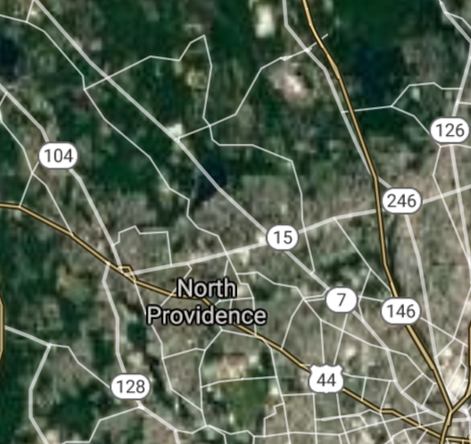
North Providence [*elevation ceiling = 40km]Elevation: 55m (Group 214)
UR-100N (SLBM) |
Point A: 41.686990 00
Point B: 41.943855 00
Point C: 41.853552 00(300kt)
Point D: 41.447569 00
Point E: 41.703671 00
Point F: 41.820520 00
|
Point A: -71.560729 00
Point B: -71.402771 00
Point C: -71.467664 00(300kt)
Point D: -71.524667 00
Point E: -71.521502 00
Point F: -71.512617 00
|
|
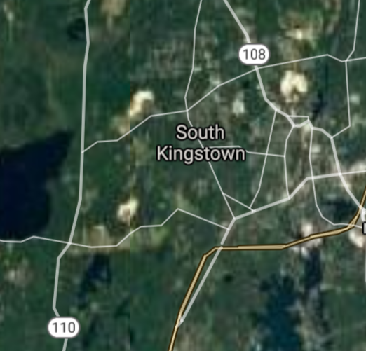
South Kingstown [*elevation ceiling = 40km]Elevation: 54m (Group 214)
UR-100N (SLBM) |
Point A: 41.686990 00
Point B: 41.943855 00
Point C: 41.853552 00
Point D: 41.447569 00(300kt)
Point E: 41.703671 00
Point F: 41.820520 00
|
Point A: -71.560729 00
Point B: -71.402771 00
Point C: -71.467664 00
Point D: -71.524667 00(300kt)
Point E: -71.521502 00
Point F: -71.512617 00
|
|
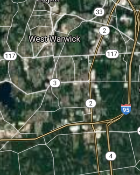
West Warwick [*elevation ceiling = 40km]Elevation: 49m (Group 214)
UR-100N (SLBM) |
Point A: 41.686990 00
Point B: 41.943855 00
Point C: 41.853552 00
Point D: 41.447569 00
Point E: 41.703671 00(300kt)
Point F: 41.820520 00
|
Point A: -71.560729 00
Point B: -71.402771 00
Point C: -71.467664 00
Point D: -71.524667 00
Point E: -71.521502 00(300kt)
Point F: -71.512617 00
|
|
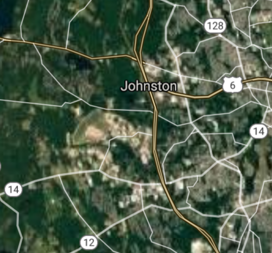
Johnston [*elevation ceiling = 40km]Elevation: 75m (Group 214)
UR-100N (SLBM) |
Point A: 41.686990 00
Point B: 41.943855 00
Point C: 41.853552 00
Point D: 41.447569 00
Point E: 41.703671 00
Point F: 41.820520 00(300kt)
|
Point A: -71.560729 00
Point B: -71.402771 00
Point C: -71.467664 00
Point D: -71.524667 00
Point E: -71.521502 00
Point F: -71.512617 00(300kt)
|
|
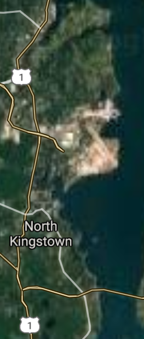
North Kingstown [*elevation ceiling = 40km]Elevation: 11m (Group 215)
UR-100N (SLBM) |
Point A: 41.556832 00(300kt)
Point B: 41.490102 00
Point C: 41.677110 00
Point D: 41.377599 00
Point E: 41.922050 00
Point F: 41.911012 00
|
Point A: -71.453684 00(300kt)
Point B: -71.312829 00
Point C: -71.266202 00
Point D: -71.827287 00
Point E: -71.549510 00
Point F: -71.441810 00
|
|
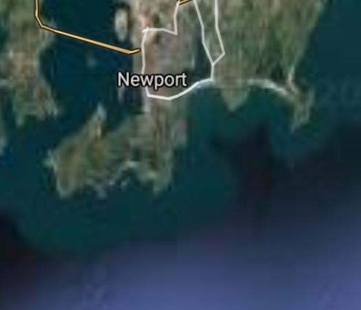
Newport [*elevation ceiling = 40km]Elevation: 8m (Group 215)
UR-100N (SLBM) |
Point A: 41.556832 00
Point B: 41.490102 00(300kt)
Point C: 41.677110 00
Point D: 41.377599 00
Point E: 41.922050 00
Point F: 41.911012 00
|
Point A: -71.453684 00
Point B: -71.312829 00(300kt)
Point C: -71.266202 00
Point D: -71.827287 00
Point E: -71.549510 00
Point F: -71.441810 00
|
|
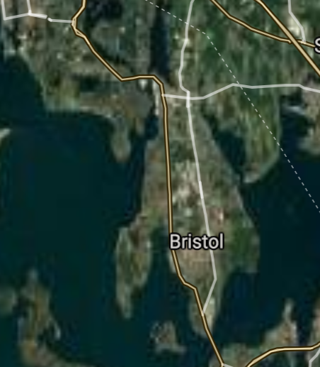
Bristol [*elevation ceiling = 40km]Elevation: 23m (Group 215)
UR-100N (SLBM) |
Point A: 41.556832 00
Point B: 41.490102 00
Point C: 41.677110 00(300kt)
Point D: 41.377599 00
Point E: 41.922050 00
Point F: 41.911012 00
|
Point A: -71.453684 00
Point B: -71.312829 00
Point C: -71.266202 00(300kt)
Point D: -71.827287 00
Point E: -71.549510 00
Point F: -71.441810 00
|
|
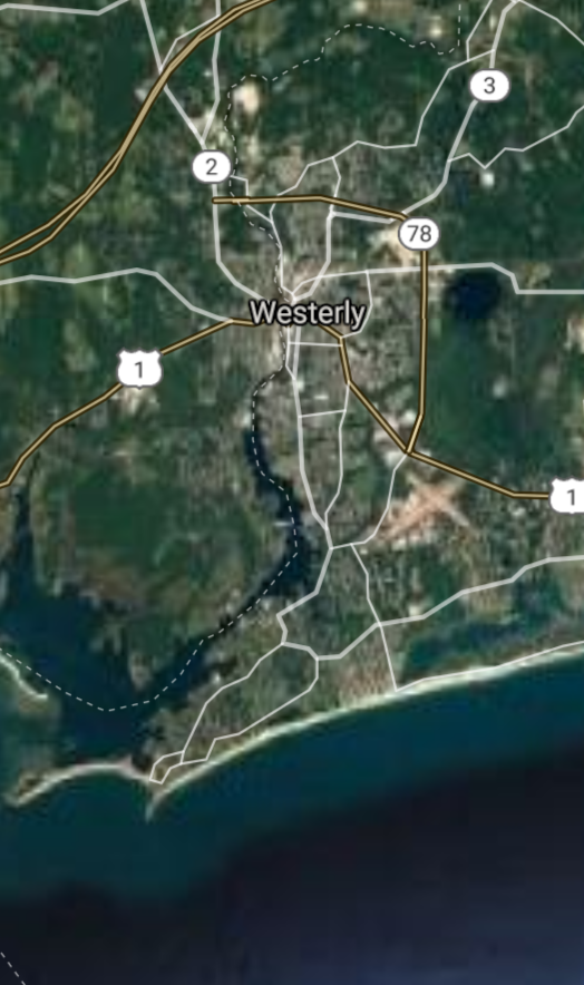
Westerly [*elevation ceiling = 40km]Elevation: 11m (Group 215)
UR-100N (SLBM) |
Point A: 41.556832 00
Point B: 41.490102 00
Point C: 41.677110 00
Point D: 41.377599 00(300kt)
Point E: 41.922050 00
Point F: 41.911012 00
|
Point A: -71.453684 00
Point B: -71.312829 00
Point C: -71.266202 00
Point D: -71.827287 00(300kt)
Point E: -71.549510 00
Point F: -71.441810 00
|
|
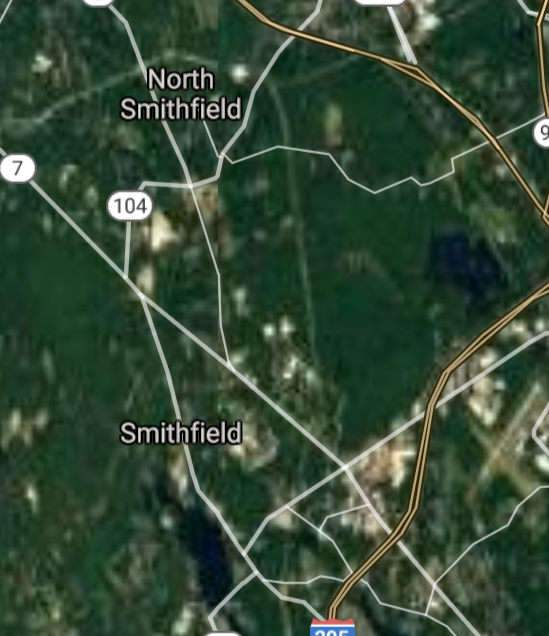
Smithfield [*elevation ceiling = 40km]Elevation: 78m (Group 215)
UR-100N (SLBM) |
Point A: 41.556832 00
Point B: 41.490102 00
Point C: 41.677110 00
Point D: 41.377599 00
Point E: 41.922050 00(300kt)
Point F: 41.911012 00
|
Point A: -71.453684 00
Point B: -71.312829 00
Point C: -71.266202 00
Point D: -71.827287 00
Point E: -71.549510 00(300kt)
Point F: -71.441810 00
|
|
Lincoln [*elevation ceiling = 40km]Elevation: 46m (Group 215)
UR-100N (SLBM) |
Point A: 41.556832 00
Point B: 41.490102 00
Point C: 41.677110 00
Point D: 41.377599 00
Point E: 41.922050 00
Point F: 41.911012 00(300kt)
|
Point A: -71.453684 00
Point B: -71.312829 00
Point C: -71.266202 00
Point D: -71.827287 00
Point E: -71.549510 00
Point F: -71.441810 00(300kt)
|
|
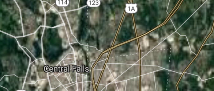
Central Falls [*elevation ceiling = 40km]Elevation: 26m (Group 216)
UR-100N (SLBM) |
Point A: 41.890655 00(300kt)
Point B: 41.602324 00
Point C: 41.740680 00
Point D: 41.521824 00
Point E: 41.966117 00
Point F: 41.450084 00
|
Point A: -71.392278 00(300kt)
Point B: -71.250326 00
Point C: -71.308609 00
Point D: -71.283454 00
Point E: -71.684725 00
Point F: -71.449503 00
|
|
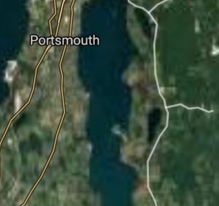
Portsmouth [*elevation ceiling = 40km]Elevation: 43m (Group 216)
UR-100N (SLBM) |
Point A: 41.890655 00
Point B: 41.602324 00(300kt)
Point C: 41.740680 00
Point D: 41.521824 00
Point E: 41.966117 00
Point F: 41.450084 00
|
Point A: -71.392278 00
Point B: -71.250326 00(300kt)
Point C: -71.308609 00
Point D: -71.283454 00
Point E: -71.684725 00
Point F: -71.449503 00
|
|
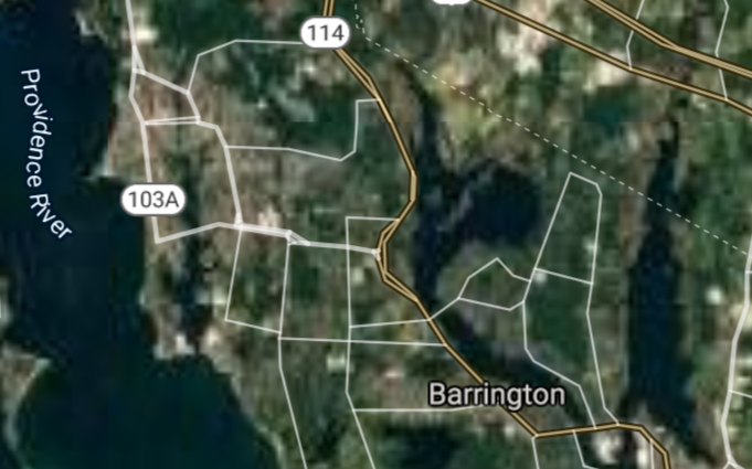
Barrington [*elevation ceiling = 40km]Elevation: 9m (Group 216)
UR-100N (SLBM) |
Point A: 41.890655 00
Point B: 41.602324 00
Point C: 41.740680 00(300kt)
Point D: 41.521824 00
Point E: 41.966117 00
Point F: 41.450084 00
|
Point A: -71.392278 00
Point B: -71.250326 00
Point C: -71.308609 00(300kt)
Point D: -71.283454 00
Point E: -71.684725 00
Point F: -71.449503 00
|
|
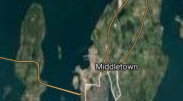
Middletown [*elevation ceiling = 40km]Elevation: 44m (Group 216)
UR-100N (SLBM) |
Point A: 41.890655 00
Point B: 41.602324 00
Point C: 41.740680 00
Point D: 41.521824 00(300kt)
Point E: 41.966117 00
Point F: 41.450084 00
|
Point A: -71.392278 00
Point B: -71.250326 00
Point C: -71.308609 00
Point D: -71.283454 00(300kt)
Point E: -71.684725 00
Point F: -71.449503 00
|
|
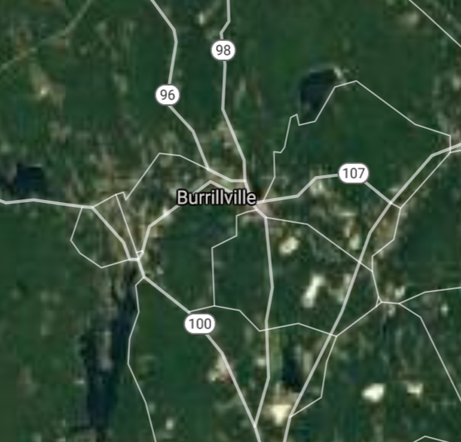
Burrillville [*elevation ceiling = 40km]Elevation: 109m (Group 216)
UR-100N (SLBM) |
Point A: 41.890655 00
Point B: 41.602324 00
Point C: 41.740680 00
Point D: 41.521824 00
Point E: 41.966117 00(300kt)
Point F: 41.450084 00
|
Point A: -71.392278 00
Point B: -71.250326 00
Point C: -71.308609 00
Point D: -71.283454 00
Point E: -71.684725 00(300kt)
Point F: -71.449503 00
|
|
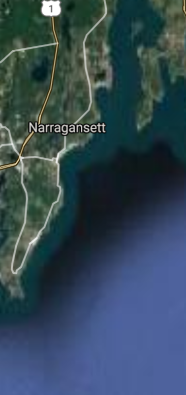
Narragansett [*elevation ceiling = 40km]Elevation: 5m (Group 216)
UR-100N (SLBM) |
Point A: 41.890655 00
Point B: 41.602324 00
Point C: 41.740680 00
Point D: 41.521824 00
Point E: 41.966117 00
Point F: 41.450084 00(300kt)
|
Point A: -71.392278 00
Point B: -71.250326 00
Point C: -71.308609 00
Point D: -71.283454 00
Point E: -71.684725 00
Point F: -71.449503 00(300kt)
|
|
Tiverton [*elevation ceiling = 40km]Elevation: 4m (Group 217)
UR-100N (SLBM) |
Point A: 41.625921 00(300kt)
Point B: 41.661501 00
Point C: 41.966765 00
Point D: 41.730379 00
Point E: 41.796450 00
Point F: 41.904311 00
|
Point A: -71.213423 00(300kt)
Point B: -71.425802 00
Point C: -71.549507 00
Point D: -71.282549 00
Point E: -71.619869 00
Point F: -71.691066 00
|
|
East Greenwich [*elevation ceiling = 40km]Elevation: 16m (Group 217)
UR-100N (SLBM) |
Point A: 41.625921 00
Point B: 41.661501 00(300kt)
Point C: 41.966765 00
Point D: 41.730379 00
Point E: 41.796450 00
Point F: 41.904311 00
|
Point A: -71.213423 00
Point B: -71.425802 00(300kt)
Point C: -71.549507 00
Point D: -71.282549 00
Point E: -71.619869 00
Point F: -71.691066 00
|
|
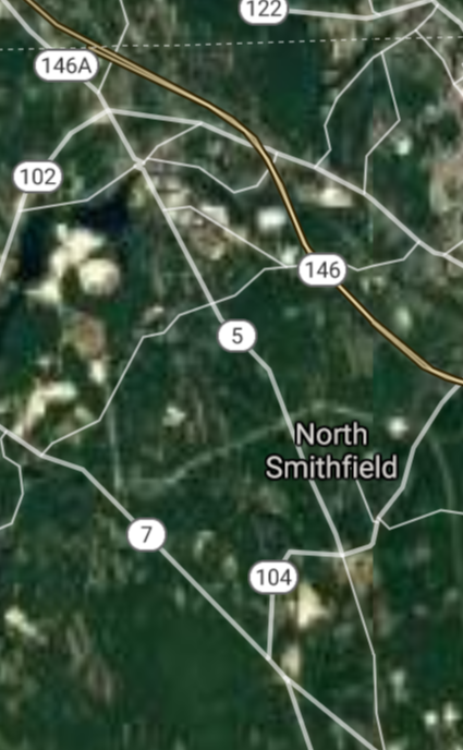
North Smithfield [*elevation ceiling = 40km]Elevation: 99m (Group 217)
UR-100N (SLBM) |
Point A: 41.625921 00
Point B: 41.661501 00
Point C: 41.966765 00(300kt)
Point D: 41.730379 00
Point E: 41.796450 00
Point F: 41.904311 00
|
Point A: -71.213423 00
Point B: -71.425802 00
Point C: -71.549507 00(300kt)
Point D: -71.282549 00
Point E: -71.619869 00
Point F: -71.691066 00
|
|
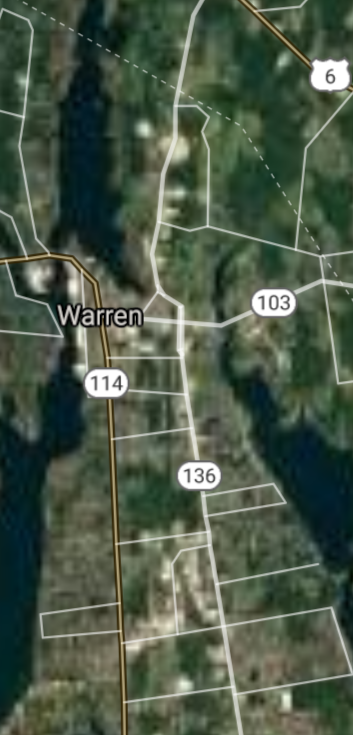
Warren [*elevation ceiling = 40km]Elevation: 9m (Group 217)
UR-100N (SLBM) |
Point A: 41.625921 00
Point B: 41.661501 00
Point C: 41.966765 00
Point D: 41.730379 00(300kt)
Point E: 41.796450 00
Point F: 41.904311 00
|
Point A: -71.213423 00
Point B: -71.425802 00
Point C: -71.549507 00
Point D: -71.282549 00(300kt)
Point E: -71.619869 00
Point F: -71.691066 00
|
|
Scituate [*elevation ceiling = 40km]Elevation: 123m (Group 217)
UR-100N (SLBM) |
Point A: 41.625921 00
Point B: 41.661501 00
Point C: 41.966765 00
Point D: 41.730379 00
Point E: 41.796450 00(300kt)
Point F: 41.904311 00
|
Point A: -71.213423 00
Point B: -71.425802 00
Point C: -71.549507 00
Point D: -71.282549 00
Point E: -71.619869 00(300kt)
Point F: -71.691066 00
|
|
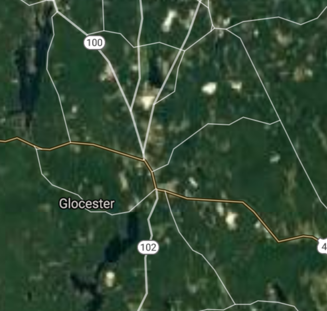
Glocester [*elevation ceiling = 40km]Elevation: 154m (Group 217)
UR-100N (SLBM) |
Point A: 41.625921 00
Point B: 41.661501 00
Point C: 41.966765 00
Point D: 41.730379 00
Point E: 41.796450 00
Point F: 41.904311 00(300kt)
|
Point A: -71.213423 00
Point B: -71.425802 00
Point C: -71.549507 00
Point D: -71.282549 00
Point E: -71.619869 00
Point F: -71.691066 00(300kt)
|
|
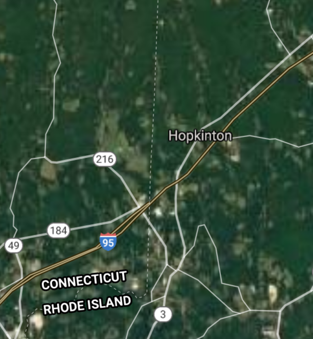
Hopkinton [*elevation ceiling = 40km]Elevation: 51m (Group 218)
UR-100N (SLBM) |
Point A: 41.461272 00(300kt)
Point B: 41.383216 00
Point C: 41.494476 00
Point D: 41.575068 00
Point E: 41.628550 00
Point F: 41.496313 00
|
Point A: -71.777550 00(300kt)
Point B: -71.641874 00
Point C: -71.670836 00
Point D: -71.535148 00
Point E: -71.663813 00
Point F: -71.371166 00
|
|
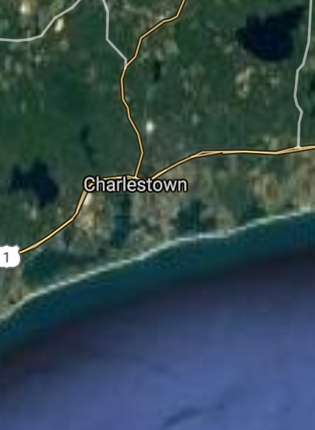
Charlestown [*elevation ceiling = 40km]Elevation: 5m (Group 218)
UR-100N (SLBM) |
Point A: 41.461272 00
Point B: 41.383216 00(300kt)
Point C: 41.494476 00
Point D: 41.575068 00
Point E: 41.628550 00
Point F: 41.496313 00
|
Point A: -71.777550 00
Point B: -71.641874 00(300kt)
Point C: -71.670836 00
Point D: -71.535148 00
Point E: -71.663813 00
Point F: -71.371166 00
|
|
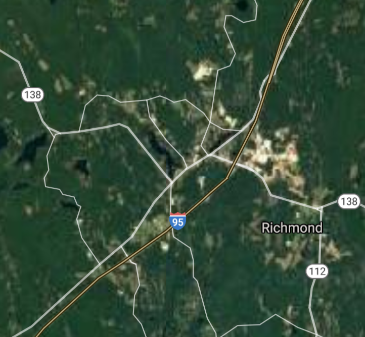
Richmond [*elevation ceiling = 40km]Elevation: 37m (Group 218)
UR-100N (SLBM) |
Point A: 41.461272 00
Point B: 41.383216 00
Point C: 41.494476 00(300kt)
Point D: 41.575068 00
Point E: 41.628550 00
Point F: 41.496313 00
|
Point A: -71.777550 00
Point B: -71.641874 00
Point C: -71.670836 00(300kt)
Point D: -71.535148 00
Point E: -71.663813 00
Point F: -71.371166 00
|
|
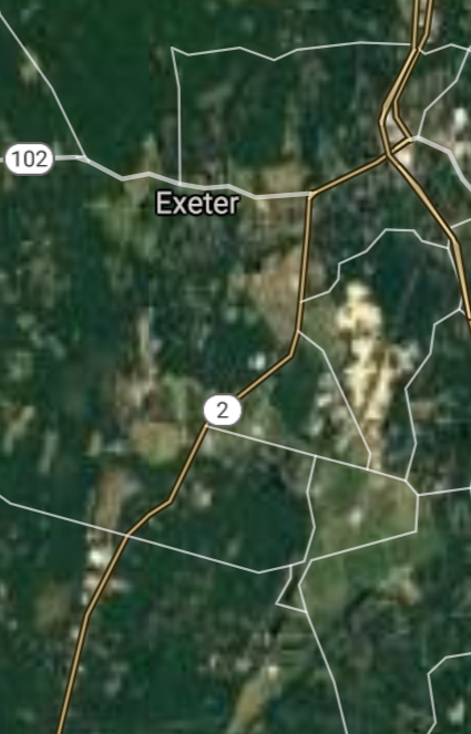
Exeter [*elevation ceiling = 40km]Elevation: 84m (Group 218)
UR-100N (SLBM) |
Point A: 41.461272 00
Point B: 41.383216 00
Point C: 41.494476 00
Point D: 41.575068 00(300kt)
Point E: 41.628550 00
Point F: 41.496313 00
|
Point A: -71.777550 00
Point B: -71.641874 00
Point C: -71.670836 00
Point D: -71.535148 00(300kt)
Point E: -71.663813 00
Point F: -71.371166 00
|
|
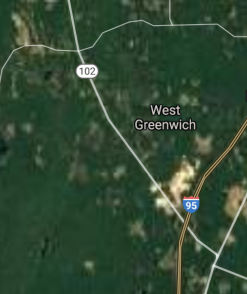
West Greenwich [*elevation ceiling = 40km]Elevation: 141m (Group 218)
UR-100N (SLBM) |
Point A: 41.461272 00
Point B: 41.383216 00
Point C: 41.494476 00
Point D: 41.575068 00
Point E: 41.628550 00(300kt)
Point F: 41.496313 00
|
Point A: -71.777550 00
Point B: -71.641874 00
Point C: -71.670836 00
Point D: -71.535148 00
Point E: -71.663813 00(300kt)
Point F: -71.371166 00
|
|
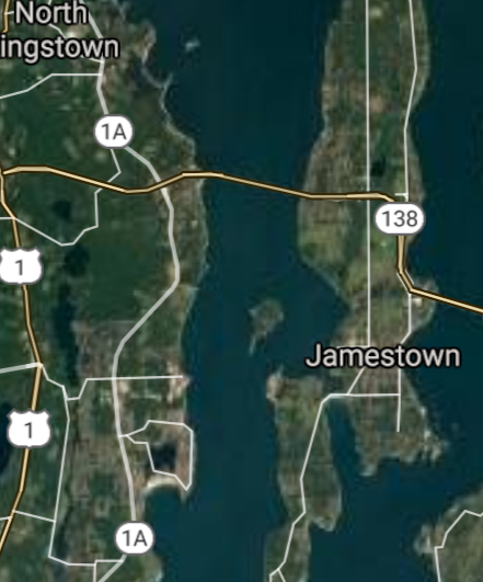
Jamestown [*elevation ceiling = 40km]Elevation: 13m (Group 218)
UR-100N (SLBM) |
Point A: 41.461272 00
Point B: 41.383216 00
Point C: 41.494476 00
Point D: 41.575068 00
Point E: 41.628550 00
Point F: 41.496313 00(300kt)
|
Point A: -71.777550 00
Point B: -71.641874 00
Point C: -71.670836 00
Point D: -71.535148 00
Point E: -71.663813 00
Point F: -71.371166 00(300kt)
|

[Top]
Open START Drills: Central Basin
![]()
![]()
![]()
![]()
![]()
![]()
![]()
![]()
![]()
JanuaryFebruaryMarchAprilJuneJulySeptemberOctoberDecember |
2024
|
|

JanuaryFebruaryJuneJulyAugustOctoberNovemberDecember |
2024
|
|

JanuaryFebruaryJuneJulySeptemberOctoberNovemberDecember |
2024
|
|
